Map

Bird’s Eye View of Cairo, Illinois: Key Federal Outpost

Bird's Eye View of Cairo, and junction of the Ohio and Mississippi Rivers

Bird’s Eye View of Cairo, and junction of the Ohio and Mississippi Rivers

Cairo [pronounced locally as “Kay-roh”], at the southern-most point of Illinois, was one of the key strategic locations for the first two years of the Civil War.

A muddy and rough riverport, Cairo lay at the junction of the Mississippi and Ohio Rivers, and potentially held the key to entering the Western Confederacy by water… up (or down) the Ohio and then into Kentucky and Tennessee by way of the Cumberland and Tennessee Rivers.  It was also a key rail junction, the southern terminus of the Illinois Central Railroad.

From the earliest days of the war, its military value had been clear and it had been garrisoned and fortified, first by the Illinois militia (rushed down on the Illinois Central), and later by an astounding assortment of Army and Navy forces based at “Fort Defiance” under Brigadier General U.S. Grant (commander of the District of Cairo).

By late 1861, the early Illinois troops would be joined by thousands more, and a fleet of ironclad river gunboats constructed by engineering genius James B. Eads. There the Federals engaged in a stand-off, and light sparring, with a Confederate army under General Leonidas Polk. In early ’62, Grant’s amphibious host, swollen by a fleet of transport steamers from St. Louis, would ascend the Ohio to begin the successful attacks on Forts Henry and Donelson, which would crack open the defense-line of the Western Confederacy and flank Polk out of his defenses.

The map is an extraordinary one. 19th Century maps can be artistic as well as informative, and this wonderful piece more than most. In the 1850s and 60s illustrator John Bachmann created a number of astonishing “Bird’s Eye” depictions of towns and regions, and here he gives the junction of the two mighty rivers his unique treatment. He defies convention by putting south at the top of the image, with the Mississippi entering from the bottom right, and the Ohio from the bottom left, to converge at Cairo, and them ascend south up (!) past Memphis towards the far off Gulf of Mexico.

Bachmann gives us a busy mix of the natural and man-made with streams, bluffs, swamps and groves, dotted with named towns and criss-crossed with road, rail, and bridges. Steamers ply the waters and Tennessee and the Cumberland…targets of Grant’s invasion in a year’s time… reach off to the left from either side of Smithland, KY.

Levee-bound Cairo is in the center foreground, with its shipyard suburb or Mound City, destined to be the headquarters of the Western Gunboat Flotilla (later the Mississippi River Squadron). Just south of Cairo is (on the left) Columbus, KY and around a short bend (to the right) Island No 10 and New Madrid, MO. All would be occupied by the Confederacy, and Columbus’ towering heights would be fortified by the CSA as the “Gibraltar of the West”. This vaunted outpost was destined to be flanked by Grant in February, 1862 and abandoned without a fight.

All that is in the future here though. Bachmann shows us Cairo and the great confluence, in the last moments of peace in 1861. He also shows us all of the terrain…human, terrestrial, and riverine…which would define the War in the West in the crucial early months of 1862.
Categories: Map | Tags: , , , , , , , , , , , , | Leave a comment

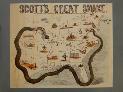
The Anaconda Plan (and much more) in period imagery

Image

The Anaconda Plan, is the (retrospectively) un-ironic name given to the much modified but eventually successful Federal Grand Strategy to win the Civil War.

The (very) rough outlines of the plan were sketched out by U.S. Army General-in-Chief Brevet Lieutenant General Winfield Scott in May of 1861.

Image

General Scott envisioned a grand envelopment (a crushing Anaconda in the public mind) which would divide, isolate, and economically cripple the seceded states. Scott wished to avoid a “war of conquest” if possible, so he called for a naval blockade to isolate the seceded states from foreign markets and imported goods. His main military action was to be a huge offensive down the Mississippi River, seizing key points along this strategic artery to put in under Federal control all the way down to the Gulf of Mexico.

“The object being to clear out and keep open this great [riverine] line of communication in connection with a strict blockade of the sea-board, so as to envelope the insurgent States and bring them to terms with less bloodshed than by any other plan.” [LTG Winfield Scott letter to MG George McClelland, May 21, 1861]

Scott did not wish to have to force the “insurgent States” back into the Union as “conquered provinces”, and he believed that there was significant “latent Unionism” in the seceded states which might be rekindled (a view Lincoln shared at the time). Isolation from foreign markets, a drought of luxuries, and economic collapse might, in Scott’s mind, bring many of the insurgents back into the U.S. with a minimum of destruction.

At the time Scott’s concept was widely derided. The label “Anaconda Plan”…or “Scott’s Great Snake”….came from enemies of the Plan, or of the Administration. Unionist fire-brands who supported a more direct “on to Richmond” strategy dismissed it as passive and weak. Peace Democrats and Confederate commentators dismissed it as doomed to fail, and as foolishly underestimating Confederate determination to break away.

In the end, Scott DID underestimate the Confederate will to fight and willingness to accept privation to achieve independence. The Confederate population proved willing to not only forgo luxuries, but bore up under economic collapse and serious food shortage. Still, Scott was right that the blockade would be a key to victory, and that a long complex campaign on the Mississippi (far from the dueling capitals) would be vital to eventual success.

Scott also saw something that few did at the time: that it would be a hard, LONG war. At the time of the plan’s origination, most Federal volunteer troops were “Three Months Volunteers”, mustered for 90 days service under the Militia Act of 1795. Scott had little use for the Three Months Men, as they could hardly be armed and partially trained before them would be mustered out. His main hope for these short-term volunteers was that they might receive some military instruction during that period, so they could be more useful as recruits for future “Three Year Regiments”. At the time, many commentators, North and South, still believed the war would be over in a matter of months.

Scott’s plan for the (Anaconda-like) slow crushing of the Confederate economy, was eventually put into place, although with the addition of the conquest and attrition Scott hoped to avoid.

The wonderful graphic of “Scott’s Great Snake” presents a great Federal “Anaconda” …studded with Navy ships…..wrapping around the southern states, and curling around to plunge, snake head-first down the Mississippi. It was created by J. B. Elliott of Cincinnati in 1861.

But in addition to the Great Snake there are numerous other miniature images, often commenting on current (to 1861) views of states or recent events. The snake’s tail is anchored to an American Flag at Washington, topped with a liberty cap.

A enthusiastic zouave, in puffy red pants, charges out of New York, as a winged helmet emblazoned “Free Trade” hovers overhead.

Maryland declares “We give in” as a bridge burns on the MD/VA border.

A West Virginian defends “The Old Flag” with a sword, as the rest of Virgina is symbolized by a battered bee hive, topped with a tattered Confederate Flag [First National pattern] hanging from a broken staff.

A North Carolinian notes that pine rosin is “Poor Eating”, while “Contrabands” escape slavery in South Carolina.

The Georgian cotton factory is abandoned and wrecked, while a lone Floridian sits in a swamp.

A proud Alabamian is angry that “Dam old Virginai took our Capitol”, because the CSA capitol was transferred from Mongomery, AL to Richmond. 😦

Some of the cartoons are grim or horrible. Rebelling slaves (apparently) are “burning massa out” as a plantation burns. In Louisiana a “Union Man” is hung while locals complain that they can’t ship out their cotton. Next door in Texas  a planter shoots fleeing slaves, noting  it is “costly shooting $100,000 a head”

Kentucky….wearing a coonskin cap…. perches on the fence, trying to maintain “Armed Neutrality”

Tennessee is divided, with the Unionist  “Knocksville [Knoxville] Whig” [Newspaper] leading East Tennesseans in defending the American Flag. In West Tennessee a secessionist in a cocked hat looks for threats across the Mississippi.

Scott's Great Snake-Jackson

There, the Great Snake is chasing out Missouri’s secessionist Governor, Claiborne Fox Jackson (the fleeing jackass), while an over-armed Arkansan wields two Bowie Knives and wearing two muskets over his shoulders.

A native chief smokes a pipe in Indian Territory [Oklahoma today], while in “Kanzas”, marching feet make “Union Music”. A second battalion of “Hawk-Eye Marksmen” march south, while a cannon points south from the Federal redoubt at Cairo [pronounced Kay-Roh] Illinois, where Ft Defiance guards the junction of the Ohio and the Mississippi.

A detailed examination of “Scott’s Great Snake” can be made at the Library of Congress:

http://memory.loc.gov/cgi-bin/map_item.pl?data=/home/www/data/gmd/gmd370/g3701/g3701s/cw0011000.jp2&style=gmd&itemLink=r?ammem/gmd:@field%28NUMBER+@band%28g3701s+cw0011000%29%29&title=Scott%27s%20great%20snake.%20Entered%20according%20to%20Act%20of%20Congress%20in%20the%20year%201861%20by%20J.B.%20Elliott%20of%20Cincinnati.

Categories: cartoon, Map | Tags: , , , , , , , , , , , , , | 3 Comments

Map of the Western Theater of the American Civil War_by Hal Jespersen

Western_Theater_Overview_Map_Jespersen

Map of the Western Theater of the American Civil War_by Hal Jespersen

At the link above, you will find an exceptional map showing the vast scale of the Western Theater, and the huge distances covered by the victorious Federal armies in the West. The westerners not only decisively defeated Confederate forces in their region, but marched East to capture all of the eastern Confederacy south of Virginia.

Hal Jespersen has created a large number of excellent scholarly maps of battles and campaigns of the American Civil War. You can explore them all at the link in the resource section of this blog page.

Categories: Map | Tags: , , , , , , , | Leave a comment

Blog at WordPress.com.